


Descripción de WinGPS™ Marine
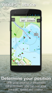
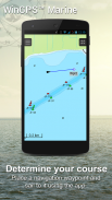
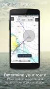
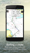
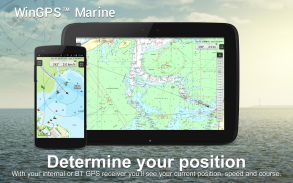
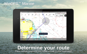
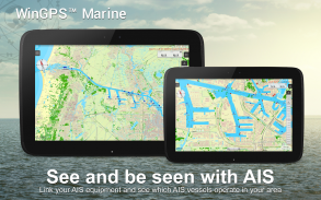
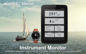
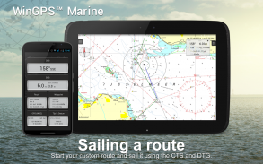
WinGPS Marine offers you modern, easy to learn navigational tools for a safe trip. Long press on the chart to plot your route. The GPS on board will show your exact location. Download the charts to your device and go boating offline with the most up-to-date charts. Connect your AIS via WIFI and prevent possible collisions.
Developed by Stentec for navigation on sailing and motor yachts, sloops and canoes at sea, tidal and inland waters. Ideal when renting or chartering a boat.
NEW [2017]
• Support for the waterways for the inland charts Western Europe and Donau with bridge-, locks and waterway information. With this you can plot and adjust your routes quickly, indicating any obstacles. The names of the waterways and distances will be shown during your trip.
• Smart labeling prevents overlapping text labels (with waterways also) for an optimal chart image. Bridge and lock data will always be readable on Course Up rotating charts.
HIGHLIGHTS
• Navigating on up-to-date charts of Stentec, Imray, NOAA and Delius Klasing.
• SD-card support for chart storage.
• Manage tracks, charts, routes and waypoints.
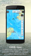
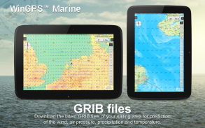
• NOAA World GRIB-files: wind, air pressure, rainfall and temperature.
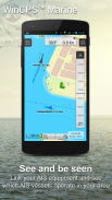
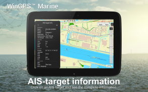
• Connect AIS and GPS via wirelesss WIFI or Bluetooth connection.
• Prevent collisions with the speed vectors of the AIS ships.
• Man-overboard button helps to retrieve lost crewmembers.
• Chart moves along underneath centered GPS position. NorthUp, CourseUp (Marine) or HeadUp (Plus).
• Harmoniemodel KNMI with detailed weather predictions (Plus, Netherlands only)
• NOAA wave prediction at open sea (Plus, Worldwide)
When WinGPS Marine is installed for the first time, this will be WinGPS Marine Lite with limited functions. Ideal as a chart viewer with GPS support.
IN-APP PURCHASE
After putchasing WinGPS Marine, you will unlock the full capabilities of your personal navigation system. You are now able to plot routes, download GRIB files, save previous tracks and connect AIS and GPS. Use the handy time table to view the predicted wind, rain, air pressure and AIS targets.
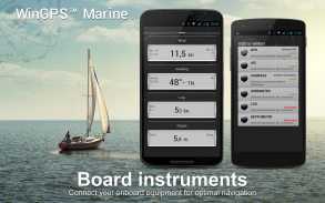
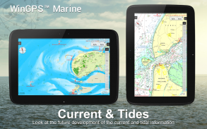
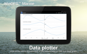
With the WinGPS Marine Plus upgrade, you will be able to connect additional board instruments via wireless connection to you board PC, multiplexer or AIS transponder. You can display current and tidal information in your data plotter or view it on the chart. Also, the advanced KNMI’s Harmonie weather model is supported as well as the NOAA waves worldwide.
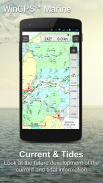
KUSTFIJN Getijmodel Rijkswaterstaat with two day wind depended predictions of currents, tides and water levels on the Waddenzee, Ijsselmeer, Markermeer, Randmeren and Zeeland. Red depth lines limit the safe waterways depending on depth, tides and deviations because of the wind.
CHART COVERAGE & INSTALLING THE CHARTS
When you start WinGPS Marine you will automatically see the (online) topographic default chart of ESRI. You can also turn on the NOAA charts of the US and download the free world chart via the Chart Manager
For safe navigation, you can purchase digital charts at www.stentec.com. It’s also possible to purchase the charts in the app or via Google Play™. Your charts can be installed on 3 different devices. For example, on your Android tablet, phone and Windows laptop or computer.
Log in with your Stentec Account in the Marine app and download or update your purchased DKW2 charts in the Chart Manager.
For example, the popular DKW1800 series with weekly BaZ updates and the NL Chart with biweekly updates. Our online shop offers up-to-date sea charts and all inland charts of Western Europa including the Donau.
With the DKW Builder (optionally), you can use scanned or BSB charts to build your own DKW2 chart set. The new DKW2 charts can be copied to the DKW2 folder on your tablet via a USB cable to use the charts in WinGPS Marine.
More information: www.wingpsmarine.com
USERS INPUT
For improvement of the app we are very much interested in your experience and suggestions. Please send an e-mail to helpdesk@stentec.com.
WinGPS Marina le ofrece moderno, fácil de aprender herramientas de navegación para un viaje seguro. pulsación larga en el gráfico para trazar su ruta. El GPS a bordo mostrará su ubicación exacta. Descargar las cartas a su dispositivo y ir en bote fuera de línea con el mayor número de cartas en marcha hasta la fecha. Conectar el AIS a través de WIFI y evitar posibles colisiones.
Desarrollado por Stentec para la navegación en vela y motor yates, barcas y canoas en aguas de mar, las mareas y del interior. Ideal cuando el alquiler o alquiler de un barco.
NEW [2017]
• El apoyo a los cursos de agua para las tablas interiores de Europa occidental y con Donau de puentes, esclusas y la información vía acuática. Con esto se puede trazar y ajustar sus rutas de forma rápida, lo que indica cualquier obstáculo. Los nombres de los cursos de agua y las distancias serán mostrados durante su viaje.
• etiquetado inteligente evita que las etiquetas de texto superpuestos (con vías de agua también) para una imagen gráfico óptimo. los datos de puentes y de presión siempre será legible en curso hasta cartas de la rotación.
REFLEJOS
• Navegar en un máximo al día tablas de Stentec, Imray, NOAA y Delius Klasing.
• Soporte de tarjeta SD para el almacenamiento de tabla.
• Gestión de pistas, gráficos, rutas y waypoints.
• GRIB-archivos de NOAA Mundo: viento, presión atmosférica, las precipitaciones y la temperatura.
• Conectar AIS y GPS a través de WIFI o Bluetooth wirelesss.
• evitar colisiones con los vectores de velocidad de los barcos AIS.
• Botón de hombre al agua ayuda a recuperar los tripulantes perdidos.
• Gráfico mueve a lo largo de posición GPS debajo centrada. Northup, CourseUp (marina) o HeadUp (Plus).
• Harmoniemodel KNMI con las predicciones meteorológicas detalladas (Plus, Netherlands)
• Predicción de onda de la NOAA en el mar abierto (Plus, todo el mundo)
Cuando WinGPS Marina se instala por primera vez, este será WinGPS Marina Lite con funciones limitadas. Ideal como un visor gráfico con la ayuda del GPS.
APLICACIÓN EN LA COMPRA
Después putchasing WinGPS Marino, que se desbloquee todas las capacidades de su sistema de navegación personal. Que ahora son capaces de trazar rutas, descargar archivos GRIB, guardar pistas anteriores y conectarse AIS y GPS. Utilice la tabla de tiempo útil para ver el viento, la lluvia, la presión del aire predicho y blancos AIS.
Con la actualización WinGPS Marina Además, usted será capaz de conectar instrumentos de mesa adicionales a través de conexión inalámbrica a usted tarjeta de circuito impreso, multiplexor o transpondedor AIS. Se puede visualizar la información actual y de las mareas en su plotter de datos o visualizarla en la tabla. También, modelo meteorológico Harmonie lo avanzado de las KNMI se apoya, así como las olas de la NOAA en todo el mundo.
KUSTFIJN Getijmodel Rijkswaterstaat con dos días de viento dependía predicciones de corrientes, mareas y los niveles de agua en el mar de Frisia, Lago IJssel, Markermeer, Randmeren y Zelanda. líneas de profundidad de color rojo limitan los cursos de agua seguras, según la profundidad, las mareas y las desviaciones a causa del viento.
TABLA DE COBERTURA Y INSTALACIÓN DE LAS CARTAS
Al iniciar WinGPS Marina verá automáticamente el (en línea) de gráfico predeterminado topográfico de ESRI. También se puede activar en las listas de la NOAA de los EE.UU. y descarga el gráfico mundo libre a través del Administrador de gráficos
Para una navegación segura, puede comprar cartas digitales en www.stentec.com. También es posible comprar las listas de éxitos en la aplicación o a través de Google Play ™. Sus gráficos se pueden instalar en 3 dispositivos diferentes. Por ejemplo, en la tableta androide, teléfono y Windows ordenador portátil o un ordenador.
Inicia sesión con tu cuenta de Stentec en la aplicación marina y descargar o actualizar sus tablas DKW2 adquiridos en el Administrador de gráficos.
Por ejemplo, la popular serie de DKW1800 con actualizaciones semanales Baz y la Tabla de NL con actualizaciones cada dos semanas. Nuestra tienda en línea ofrece hasta a la fecha de cartas de navegación y todos los gráficos del interior de Europa Occidental, incluyendo el Donau.
Con el DKW Builder (opcionalmente), se puede utilizar gráficos escaneadas o BSB a construir su propio sistema gráfico de DKW2. Las nuevas cartas DKW2 se pueden copiar en la carpeta DKW2 en su tableta a través de un cable USB para utilizar las listas en WinGPS marina.
Más información: www.wingpsmarine.com
USUARIOS DE ENTRADA
Para la mejora de la aplicación que estamos muy interesados en su experiencia y sugerencias. Por favor envíe un correo electrónico a helpdesk@stentec.com.
WinGPS™ Marine - Versión 4.60
(09-02-2024)
WinGPS™ Marine - Información de APK
Version de la app: 4.60Paquete: com.stentec.wingps_marine_liteApps en la misma categoría
Quizá también te interese...


